NASA images show largest reservoir in US is disappearing
New images from NASA show the dramatic decline in the water level of Lake Mead – the largest reservoir in the United States.
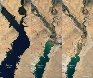
The light-coloured fringes along the shorelines in images taken in 2021 and 2022 are mineralised areas of the lakeshore that were formerly underwater when the reservoir was filled closer to capacity. The phenomenon is often referred to as a ‘bathtub ring’.
According to the NASA Earth observatory, water levels in Lake Mead are continuing a 22-year downward trend and stand at their lowest since April 1937, when the reservoir was still being filled for the first time.
As of 18 July 2022, Lake Mead was filled to just 27 per cent capacity. Lake Mead is a national recreation area that is particularly popular with boaters. According to the National Park Service, five of six boating ramps/launches are now closed. ‘Declining water levels due to climate change and 20 years of ongoing drought have reshaped the park’s shorelines,’ the Park Service said on its website. ‘As Lake Mead continues to recede, extending launch ramps becomes more difficult and more expensive due to the topography and projected decline in water levels.’
The natural-colour images were acquired by Landsat 7 and Landsat 8.
Lake Mead supplies water to millions of people across seven states, tribal lands, and northern Mexico. It now also provides a stark illustration of climate change and a long-term drought that may be the worst in the US west in 12 centuries, NASA says.
The low water level comes at a time when 74 per cent of nine western US states face some level of drought with 35 per cent of the area in extreme or exceptional drought.
Images courtesy of NASA Earth Observatory. Images by Lauren Dauphin, using Landsat data from the US Geological Survey and and lake elevation data from the Bureau of Reclamation.
