Video: Digital mapping showcases Titanic in 3D
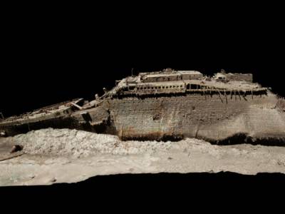
The world’s most famous shipwreck has been revealed as never seen before. The first full-sized digital scan of the Titanic, which lies 3,800m (12,500ft) down in the Atlantic, has been created using deep-sea mapping. Through the largest underwater 3D capture project ever undertaken, research scientists have mapped the ship in its entirety.
From this data a ‘Digital Twin’ has been created that shows the wreck to a level of detail and clarity never seen before. Using technology developed and perfected over five years by Magellan, the exact condition of the wreck is revealed and the entire historic site is mapped.
El primer escaneado en 3D del Titanic revela restos inéditos del naufragio. Esta tecnología puede ayudar a determinar con mayor precisión las condiciones del famoso hundimiento del transatlántico en 1912 https://t.co/QKD4Hxk5z3
— EL PAÍS (@el_pais) May 17, 2023Atlantic Productions/Magellan pic.twitter.com/oibk4HAe70
Scans of the wreck were carried out over a six week expedition in the summer of 2022. A specialist ship was positioned in the North Atlantic 700km off the coast of Canada. The expedition deployed two submersibles – named Romeo and Juliet – which spent many hours at 3,800 metres (12,500ft) below the surface mapping every millimetre of the wreck in minute detail and mapping the entire three-mile debris field. They took more than 700,000 images from every angle, creating an exact 3D reconstruction.
In accordance with tight regulations, says Atlantic Productions (which is making a documentary about the project), the wreck was not touched or disturbed, and the entire site treated with the utmost of respect, which included a flower laying ceremony in memory of those who lost their lives.
The project now provides a unique 3D view of the entire ship, enabling it to be seen as if the water has been drained away. The hope is that this will shed new light on exactly what happened to the liner, which sank in 1912, says Magellan.
“There are still questions, basic questions, that need to be answered about the ship,” Parks Stephenson, a Titanic analyst, told BBC News.
He said the model was “one of the first major steps to driving the Titanic story towards evidence-based research – and not speculation.”
The wreck lies in two parts, with the bow and the stern separated by about 800m (2,600ft). A huge debris field surrounds the broken vessel.
The Titanic was long assumed to have sunk in one piece, but when the wreck was discovered in 1985 it was found to have broken up before reaching the ocean floor.
The lack of light and intense pressure at a depth of nearly 2.5 miles (4km) means there is little sea life in the vicinity. But iron-eating microbes have colonised the vessel and are gradually transforming the 50,000 tonnes of iron into rusticles. These eventually dissolve into a fine powder and are carried away on ocean currents, reports The Guardian.
Magellan’s Gerhard Seiffert, who led the planning for the expedition, told the BBC it was the largest underwater scanning project he’d ever undertaken.
“The depth of it, almost 4,000m, represents a challenge, and you have currents at the site, too – and we’re not allowed to touch anything so as not to damage the wreck,” he says.
“And the other challenge is that you have to map every square centimetre – even uninteresting parts, like on the debris field you have to map mud, but you need this to fill in between all these interesting objects.”
Parks Stephenson, who has studied the Titanic for many years, told the BBC he was “blown away” when he first saw the scans.
“It allows you to see the wreck as you can never see it from a submersible, and you can see the wreck in its entirety, you can see it in context and perspective. And what it’s showing you now is the true state of the wreck.”
He says that studying the scans could offer new insight into what happened to the Titanic on that fateful night of 1912.
“We really don’t understand the character of the collision with the iceberg. We don’t even know if she hit it along the starboard side, as is shown in all the movies – she might have grounded on the iceberg,” he says.
In September 2022, Oceangate Expeditions released the first ever 8K resolution footage of the RMS Titanic. Since its discovery in 1985, fewer than 250 people have personally viewed the wreck of the Titanic. Oceangate is conducting a multi-year mission to document the Titanic’s rate of decay.
'We now have every rivet of the Titanic'
— BBC Breakfast (@BBCBreakfast) May 17, 2023
Andrew Geffen from Atlantic Productions spoke to #BBCBreakfast after about the first full-sized digital scan of the Titanic which has been created using deep-sea mapping.https://t.co/DZyzkoSRd7 pic.twitter.com/jCveKN0Zxf
The post Video: Digital mapping showcases Titanic in 3D appeared first on Marine Industry News.